Alaska Presentation
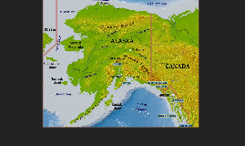
Transcript: The arctic circle is a parallel of latitude that is 66º 33' 43" (or 66.5619°) north of the Equator. Ice Fog A)In Alaska, how does Upslope Caribou affect take-off or landing distance if confronted (Best Answer)? i)It Uplifts the Aircraft’s Spirit, and distance is extende ii)Distance depends on the size and mating season, but generally distance is cut short of anything natural and distance is traded for dinner. iii)It does not affect distance whatsoever because Santa traded Downslope Reindeer for Upslope Caribou and it is no longer an issue for pilots in Alaska iv)Distance is relative, and therefore cannot not be changed. What weather phenomenon difuses and relects rays of sunlight between a cloud layer and a snow covered surface? a) Whiteout b)Ring of fire c) Flat Light d) Aurora borealis What Advisory Circular states that all control surfaces and critical components must be free of snow, frost, or other ice formations before flight? a) AC 20-117 b) AC 20-123 c) AC 20-456 d) AC 20-789 The End! Includes the Aleutian Chain and the Southeast and Southcentral regions. Temperatures are relatively mild in the winter and cool in the summer with heavy precipitation (50-200" per year). Aviation hazards: Summertime fog. Winter ice fog, blowing snow and turbulence associated with winter storms. Spring and Fall icing, turbulence, and advection fog cause icing problems which can be quite severe. Volcanoes Winter Hazards By: Eric Buntrock & Sean Lail Winds can range from 10 to 60 MPH. Where is the arctic circle? DUH! Alutian Low Pressure Where is Alaska? Questions? Area north of the Brooks Range. Cold winters & cool summers with low precipitation (3-7" per year). Summers are generally cloudy and winters are clear and cold. Aviation hazards: summertime clouds, and wintertime ice fog, winds, blowing snow and whiteouts. Geography The new requirements omit the rule of carrying a one pistol, revolver, shotgun or rifle and ammunition. Laws: The FAR & (AC) 20-117 state that all critical components, wings and flight control surfaces must be free of adhering snow, frost, or other ice formations before flight. Survival When: Febuary 19, 2009 What: Piper PA-31-350, N41185 Where: Nome, Alaska How: Landing during whiteout condition Chinook Winds: January 1990 Pressure Systems Redoubt Alaska Seasonal Visibility When: October 16, 1972 What: Cessna 310C, N1812H Where: Between Anchorage and Juneau, Alaska How: VFR flight into IFR weather Accidents C - Keep clothing CLEAN O - Avoid OVERHEATING L - Wear clothes LOOSE and in LAYERS D - Keep clothing DRY Continental AS 02.35.110. Emergency Rations and Equipment Covers the majority of Alaska. Extreme temperatures and low precipitation (5-15" per year). Aviation hazards are wintertime ice fog and summertime cloudiness, scattered cumulus occasionally grow into small thunderstorms. Exists along Alaska's western coast and in the area between the coastal mountains and the Alaska Range. This zone has less precipitation than the Maritime zone. Aviation hazard: summertime winds, and wintertime ice fog and blowing snow. Flying conditions are generally worse in mountain passes than at stations along the route. The minimum equipment to be carried during summer months is as follows: rations for each occupant sufficient to sustain life for one week; one axe or hatchet; one first aid kit; an assortment of tackle such as hooks, flies, lines, and sinkers; one knife; fire starter; one mosquito headnet for each occupant; two small signaling devices In addition to the above, the following must also be carried from October 15 to April 1 of each year: one pair of snowshoes one sleeping bag one wool blanket for each occupant over four Interesting Facts Maritime A massive dust storm of glacial sediments swept off the coast of Alaska on November 5, 2005; Summer Alaskan Survival Kit Regulations The sun is continually below the horizon from November 19th until January 23rd. It is an area of semi-permanent Low Pressure system in the winter off the Aleutian Islands in the North Pacific Fog Summer Hazards Primary Weather Factors Alaska is 365 million acres in size and has 33,000 miles of coastline. It has two time zones and seven different climactic regions. There are less than 12,000 miles of paved road in the state, so aviation is a major form of transportation. There are approximately 600 published airports and more than 3,000 airstrips. The highest recorded temperature for the state is 100 degrees in June 1915. The coldest temperature ever recorded was in Alaska, - 80 degrees on January 23, 1971. Climate Regions Snow & Ice buildup Arctic Snow and ice buildup Extreme cold White Out Conditions Flat Light: occur when a uniform ceiling overlies a snow or ice-covered surface and the parallel rays of the sun are reflected and diffused between these two surfaces. Blizzards: Visibility less than 500 feet, high winds exceeding 32 mph, temp at or below 20°F Severe Blizzard: Visibility near 0, winds in excess of 45mph, temp at


