Developing an Aerial View
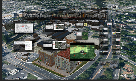
Transcript: Charles County, Maryland Downtown Development Opportunities Map | Jakubiak and Associates from A Plan For Transformation City Engine: Assigns and positions Houses Within Parcel Boundaries based on NHC value SketchUp: Created simplistic, but realistic-appearing, single family homes that are not graphics-intensive. These models are in turn called by the rule file in City Engine Google Earth: Google Earth Pro Movie Maker City Engine (ESRI) Salisbury, Maryland Using Zoning Regulations, site requirements, the 3.51 acre site can accommodate a mixed use development. 862,082 Square Feet of Floor Space with a FAR of 5.6, 47,888 Square Feet of Open Space (31%), 0 Square Feet of Parking (0%) Created a 3D representation of downtown Salisbury, along with infill scenarios for 2 existing parking lots Site design and models of buildings informed by Salisbury's local zoning code, subdivision regulations, and development standards Used SketchUp to fill-in more realistic, "iconic buildings,' and create potential infill project on gateway northern parking lot targeted for redevelopment In Remington - we utilized city-provided building footprint shapefiles along with building type data to create a City Engine rule file that exploited the number of floors (per use) While not perfect, City Engine places the SketchUp Models within the parcels so visualization can be achieved Visualizing Redevelopment O Compared to The Centre of Salisbury Mall just north of the Town Center – a total lot size of 63 acres 1,434,474 Sq Feet of Parking (52%), 309,272 Sq Feet of Open Space (11%), 861,000 Square Feet of Floor Space with a FAR of 0.3 But what if our 'rough' City Engine buildings aren't detailed enough? Now we are dealing with a 2.96 Acre Lot Again - the buildings surrounding have been created (mostly) with City Engine and are rudimentary (a few iconic buildings were touched up in SketchUp) Let's bring in a potential mixed-use building designed in SketchUp The SketchUp Models allow much more detail while still integrating with the CityEngine buildings surrounding The entire proposed development from the Town Center – the 3.51 acres – fits over a portion of just the mall’s building. Once we add in imagery from Google Earth and the road network from Open Street Map, We can see our City Engine buildings in context. Charles County, Maryland Salisbury, Maryland And once you have the surrounding buildings created from a City Engine footprint, you can make different SketchUp Models to drop into Google Earth Salisbury, Maryland Visualizing the Effects of Septic Sprawl In Charles County, we employed City Engine a bit differently. We used our state-created growth model (creates a NHC - "New Housing Capacity" index based on Zoning and acreage) to visualize houses within the County's Agricultural Zone that could potentially be built if the county alters their plan to Rural Residential use. Remington, Baltimore Remington, Baltimore 0 City Engine is rule-based 3d Modeling Learning-as-we-go with ESRI's City Engine (1 license) Follow ESRI tutorials & seek feedback Utilize building local Lidar and building footprints (when available), National Oceanic and Atmospheric Administration (NOAA - currently down), US Geological Society (USGS - currently down), and DNR So far we have modeled downtown Salisbury, the Remington Neighborhood in Baltimore, and Charles County. However we have modeled each in different capacities and for different purposes... This may not look like much - but each building is georeferenced and extruded by building type. City Engine (ESRI) ESRI City Engine | Trimble SketchUp | Google Earth Visualizing Redevelopment City Engine contains customizable code which is, relatively, easy to modify. It's dynamic. And it can provide low & high levels of detail. The Town of Salisbury is interested in redeveloping "Lot #10" at the northeastern corner of the town. Surface Parking lot can become a mixed use tax revenue generating development -- This lot is 3.51 Acres Zoning regulations utilized to develop realistic visualization of potential development Visualizing Redevelopment We can integrate Google SketchUp Modeling of existing locations to give context to our buildings generated by City-Engine


